Geology of Barbados & Antigua
Adapted from A. O. Thomas' field notes (in Nutting, 1919)
Barbados
The Greater and Lesser Antilles form a long chain which represents the tops of highlands or mountain peaks. During certain periods in geological history this land mass has connected North and South America. Barbados is set off from the chain of the Lesser Antilles by about 70-80 miles. Once in the early Tertiary it was a part of the mainland, and the oldest beds, exposed in the Scotland district, are made up of sandstones, conglomerates,and shales intermingled in places with thin beds of volcanic origin. The region was let down to great depths and beds of oceanic ooze of foraminiferal and other origin were laid down on the basic sands and shales.
The beds of foraminiferal strata are famous both for the radiolaria and foraminifera contained within them. On this particular expedition approximately one hundred pounds of this earth was collected.
Above these oceanic deposits are more recent deposits of coralline limestones. A period of uplift and coral inhabitation took place followed by subsequent slow elevations above the water. These elevations brought the now higher parts of the island above the water and gradually increased the size and elevation of the island. This event is responsible for the terraced effects which are so apparent even to the casual observer.
The shoreline of Barbados is simple and featureless; there are no islands off-shore and few indentations which offer good harbor facilities. The highest point on the island is Mt. Hillaby, at 1104 feet.
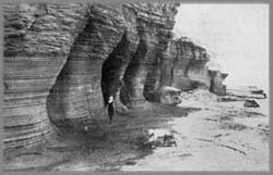
The coral limestone overlies six-seventh of the island and is extremely porous which accounts for the lack of streams on the coral limestone part of the island. Solution has dissolved out many underground passages and caves such as Coles' Cave on the Walkes Spring Estate and the Manning Cave.
The southwestern part of the island is the driest. Rainfall is much less here than on other parts of the island. The greatest rainfall is on the higher lands, every terrace has its own unique characteristics and records.
In the Scotland district occurs a variety of bitumen known as "manjak" or glance pitch. This "Barbados tar" as it is known in England, early held an important place in materia medica. Its primary use is as a basis for black varnish. Its jet black color obviates the necessity of mixing it with other pigments.
The island of Barbados is surrounded by coral reefs which encircle it except on the windward side; these reefs extend in some cases to three miles seaward. The fact that very little sediment is carried into the sea from the land except opposite the Scotland District is in favor of coral growth.
Antigua
Antigua is located about 200 miles to the north of Barbados. It forms an intimate link in the Lesser Antillean chain. Many lines of evidence support that Antigua and Barbuda have been united in relatively recent times. A study of the land snails of the two islands brings out some striking similarity, while the notable similarities of the reptiles led one scientist to remark that "Barbuda is a herpetological appendix of Antigua." These facts emphasize the recency of diastrophic movements which have been important factors in modifying the geology and distribution of life in the whole Antillean region.
The windward side of the island gives the impression of being very rough with numerous steep sided hills. There is in fact, very little flat land. Bold headlands, on whose side cling the huts of the natives, jut out into the sea; in places they alternate with swampy bay-heads, in which thrive mangroves and other halophytes. The leeward side is not so rugged but it is deeply indented by many shallow bays and fringed with a multitude of low-lying islands. The island is surprisingly dry and there are no streams of importance. The vegetation is of the xerophytic type and is very harsh and thorny.
Antigua is divided by the low central belt into nearly three equal parts. The southwestern part is hilly and rough with many peaks rising from 1,000-1,300 feet. The highest point is Boggy Peak, at 1,330 feet. The central region is lower and flatter and is indented at one end by St. John's Harbor and at the other by Falmouth and Willoughby bays. The northeastern part is rolling, with low ridges and hills of limestone marl. Since the geology of the island is different in each of these districts they may be further considered separately.
The southwestern part is generally known as the volcanic portion, and though many of the hills have the appearance of extinct volcanic cones, closer examination reveals little if any evidence of rock of recent volcanic origins. The rock is however, much metamorphosed and contains weathered and transported particles that are apparently of volcanic derivation.
The central portion extends diagonally across the island and is underlain by thin-bedded mudstones, volcanic sandstones, and conglomerates. Their lithology from point to point is variable and there is evidence that shows some of it is of marine origin. Locally, there is evidence of faulting and of folding, which features point to the complex crustal disturbances which have affected the island.
The northeastern belt is the limestone area of Antigua. The overlying soil is fertile, tractable, and marly; the region is rolling, and there are a few hills and ridges ranging from 100-400 feet above the sea. The unweathered limestone is fairly pure, crystalline, and hard. Its is Oligocene in age as the fossils attest, hence it is much older than the white limestones of Barbados.